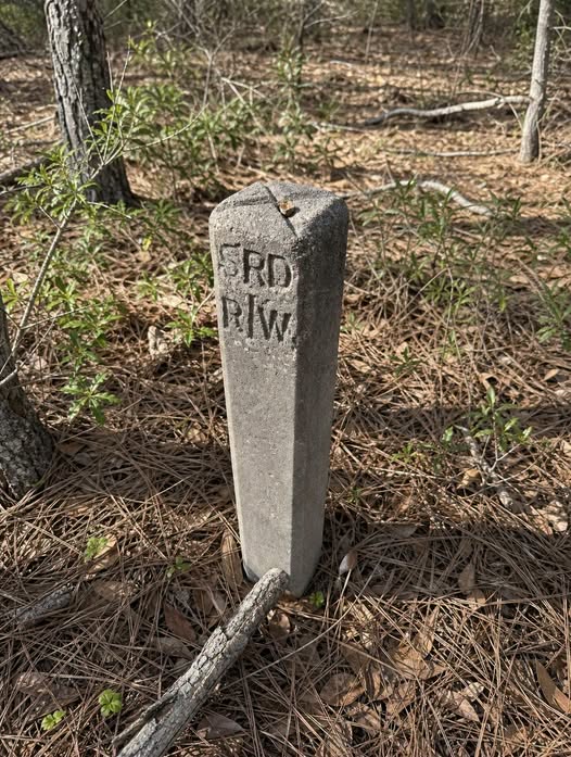
civilization, marking the precise boundary of a path that once facilitated the movement of people, goods, and progress. These markers are the physical manifestations of legal boundaries, specifically denoting the right-of-way for infrastructure that has long since been reclaimed by nature. When you encounter these posts, you are not merely looking at a piece of concrete; you are witnessing the skeletal remains of a transportation network that once defined the local geography, even if that road has completely disappeared from modern maps.
The markings etched into these posts, such as the common abbreviations “R/W” or “SRD,” serve as essential clues for those who know how to read the landscape. “R/W” stands for right-of-way, indicating the legal limit of the land designated for public or utility use, while “SRD” often refers to state road departments or similar government entities that were responsible for the original surveying and construction. These stamps were never intended to be decorative; they were utilitarian markers placed by surveyors to ensure that the public domain remained clearly defined, preventing encroachment and establishing permanent legal limits for road maintenance and future expansion.
Understanding these markers requires a shift in perspective, moving from seeing the woods as a wild, untouched space to viewing them as a layered historical site. When you spot one of these posts, look for the subtle environmental cues that accompany it. Often, these markers are situated along slight, linear depressions in the ground or parallel to raised earthen berms. These features are the ghosts of old roadbeds, railroad grades, or early carriage paths. The soil composition near these markers may also differ from the surrounding forest floor, sometimes containing crushed gravel, cinders, or non-native stone that was hauled in decades ago to stabilize the surface for transit.
The persistence of these markers is a testament to the foresight of early civil engineers. While the asphalt has long since crumbled, the vegetation has overgrown the path, and the original purpose of the route has been forgotten by the local community, the concrete remains. It is a stubborn reminder that the land we traverse today was once surveyed, planned, and utilized with a specific intent. These posts bridge the gap between the chaotic, organic growth of the forest and the rigid, structured planning of human society. They represent the intersection of legal history and environmental change, showing how quickly nature can erase the visible signs of human activity while leaving the legal markers behind to tell the tale.
As you explore further, you might notice that these markers often appear in pairs or at regular intervals. This is because they were placed to define the width of the corridor, not just the location. By identifying two markers on opposite sides of a trail, you can effectively visualize the original width of the road that once existed there. This realization changes the way you walk through the woods; instead of seeing a random path, you begin to see the intentional geometry of the past. You are walking in the footsteps of travelers who moved through this space long before the trees grew tall enough to hide their path.
Landscape archaeology is not just the study of ancient ruins or grand monuments; it is the study of the everyday infrastructure that shaped our ancestors’ lives. These concrete posts are the most accessible entry point into this field of study. They remind us that history is not always found in museums or textbooks. Sometimes, it is found knee-high in the weeds, waiting for a curious observer to notice the letters stamped into its surface. By recognizing these markers, you gain a deeper appreciation for the permanence of human planning and the inevitable, slow reclamation of that planning by the natural world.
If you find yourself frequently encountering these markers, consider keeping a record of their locations. You might be surprised to find that they align with old property lines or forgotten survey maps available through local historical societies or county archives. This practice of mapping the markers can help you reconstruct the path of a vanished road, providing a rewarding sense of discovery. It turns a simple walk in the woods into an investigative journey, allowing you to connect the dots between the past and the present in a way that few other historical artifacts allow.
Ultimately, these concrete posts serve as a practical tool for anyone interested in the history of their local area. They provide a tangible, reliable anchor point that defies the erosion of time. When you see one, take a moment to observe the surroundings, note the alignment of the terrain, and consider the people who once walked or drove along that very line. It is a simple, effective way to engage with the history of the land beneath your feet. Treat these markers with respect, as they are the last remaining witnesses to the roads that built our communities, and they deserve to be recognized for the silent, enduring history they continue to protect in the quiet corners of our forests.